Infos dragage
N°02
Why do we dredge the harbor?
Avis publié le 11 September 2021
Evry coastal harbor regularly silts up. That means that it recieves accretion of sediments (mud, sand…) that gradually disminish the actual depth for navigation. The volume of these accretions vary according to different parameters such as: The geological nature of the coastline (rocky, muddy, sandy…); The force and direction of sea currents, The vicinity of rivers, The site’s natural set up or human made modifications (Digues, channels…)
Regarding “Port La Rochelle”, the above parameters are fairly adverse: Muddy foreshore in the vicinity, important riverbed accretion from the “Sevre niortaise, the Charente and the Gironde”, strong sea currents. We estimate the total amount of sediments to nearly 50 Centimeters per year. Therefore we need to dredge evry year.
Dredging operation in few numbers :
- Campaign’s duration : 8 months
- Dredged areas : Les Minimes and its access channel, Port-Neuf’s channel and Vieux-Port.
- Dredged volume : +/-270 000 m³ of sédiments per campaign
- Dredging means : A total of 4 dredging units are operating
Witch dredging means to use?
There are several, the target is to bring those sediments back to their environment (under certain conditions). La Rochelle marina uses different means to dredge:
1) The stationnery dredge AVALIS II : This unit belongs to the department of “Charente maritime”, and is not self propeled. When she is in operation, she uses a system of mecanical poles that are oriented, and alternatively moved. For more distant moves, she has to use a towing unit. The cutter under the water moves from up to down and right to left. The cutter is equipped with a drill that grinds the mud. This mud is then pumped and mixed with seawater before being repeled thru a floating pipe.
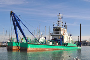
This is the dredge that you will see in les Minimes marina throughout winter and spring.
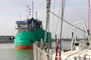
2) The self propeled dredge CAP D’AUNIS : This unit belongs to the “Port atlantique la Rochelle” and is fully autonomous. She is equipted with a moving appendice that dives to the dredging depth and aspirate sediments with seawater. This mix is stored onboard. The dredge then moves to the dedicated dumping area (see further) and opens from the middle to discharge the depot.
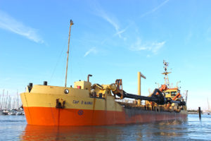
If you cruise in the main channel, between the Richelieu tower and the Vieux-Port, you will certainly meet her.
3) The self propeled dredge FORT BOYARD : This unit belongs to the department of “Charente maritime” as well and operates as the Cap d’Aunis does. In addition, she also has an excavation bucket for the less accessible areas.
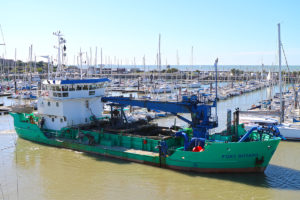
You will mainly see her operating in the access channel to “Port Neuf” and in the basins of the “Vieux Port”
4) MER D’ANTIOCHE : This last small unit also belongs to the department “Charente Maritime”. She is a kind of a small barge with a rotating hydraulic appendice at the front. She is punctually operating in small dedicated areas (slipways, quay basements). Her drilling appendice moves mud and that’s why she only operates when the tides gos down so that the mud is taken away by tides current.
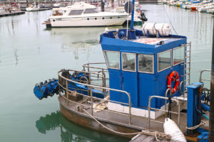
You might see this unit operating around the slipways
Wich constraints for mariners?
If self propeled dreging units have a limited impact on navigation, it is much different whith the stationnary dredge. Indeed, more than her impressive size, AVALIS II is connected to the floating dumping pipe on an important distance. The pipe has to be long enough to let the dredge cover her dredging area. The pipe also has to be stabilized by anchors on the ground. But with the winds and the tides, the pipe sometimes moves to get stuck on some pontoons, meaning that vessels can’t live their berth. It also occurs that the dredge is left the time of a weekend in a spot between two pontoons to limit the operationnal moves and and optimize dredging times.
Dredge crew are on watch on the VHF, channel 09
You will have to deal with these units during the next months. Some are massive and impressive, and will therefore bring navigation constraints.
Witch regulation prevails?
To organize the dredging campaigns, “Port la Rochelle” has several autorization from the prefecture, delivered in accordance with environment regulations, public inquiries and administration’s instructions. Those statements imply some constraints:
- Fixed period : Dredging is only permitted between the 1st of october, year Y to 15th of may the next year (Y+1). So that dredging campaing only runs thru falls, winter and spring.
- Bathymetric measures : Before and after each campaign, measures are made to prioritize the areas to clean, and the volume of sediments to take out.
- Chemical analysis : Before, during and after each campaign, certain parameters are analysed in the water as well as in the sediments. There are threshold above witch any dredging is prohibited. That’s the reason why the “Port la Rochelle” pays a lot of attention to reducing pollution sources.
- Dumping areas : Dredged sediments are rejected on precisly identified areas: around the “Lavardin Mark” for the autonomous units, “Bout du monde” lightower for the stationnery dredge. For this last site, the mud/silt mix is brought thru the floating pipe, then by an underground pipe. Those two dumping sites obviously are looked after very carrefully, bathymetricaly and chemicaly.
- Silts volume : The administrative statement fix for evry site the maximum volume that can be dredged.
